 Mount Whitney, located in California's Sierra Nevada mountains, is the highest mountain in the
48 contiguous United States. At 14,497 ft. / 4419 m. it is a very popular mountain for hikers and climbers from
all over the world. This was the first attempt on Mount Whitney for both myself and Vladimir Ulyashin, on September
28 and 29th, 2002. It was an epic trip filled with challenges and misfortune, but Vladimir succeeded in reaching the
summit of this giant mountain despite extremely dangerous conditions.
Mount Whitney, located in California's Sierra Nevada mountains, is the highest mountain in the
48 contiguous United States. At 14,497 ft. / 4419 m. it is a very popular mountain for hikers and climbers from
all over the world. This was the first attempt on Mount Whitney for both myself and Vladimir Ulyashin, on September
28 and 29th, 2002. It was an epic trip filled with challenges and misfortune, but Vladimir succeeded in reaching the
summit of this giant mountain despite extremely dangerous conditions.
There is a well-graded hiking trail that leads
to the summit of Mount Whitney for 11 miles one-way distance and 6600 feet elevation gain. Only the very fit can go up
and back down in one day,
most people will require overnight camping. Being a very popular mountain, a daily quota is imposed by the National
Forest authorities for overnight wilderness camping. There is a lottery process for
awarding permits and one must make a reservation 6 months in advance. Never having patience for bureaucratic hassles,
I haven't seriously considered climbing Whitney until just a week before this trip. Recently I had become aware that
one can climb the more technical routes on Whitney with a normal walk-in wilderness permit. The
approach is through a different draingage: North Fork of Lone Pine Creek. As crow flies it is only 4 miles to the
summit from the trailhead, with an elevation gain of about 6200 feet; however, there are no official trails
so it involves a lot of cross-country travel. The seemingly short approach is what motivated me to make an attempt
on Whitney with only two days to spend. According to various sources including RJ Secor's guidebook and summitpost.com,
there are several technically difficult climbing routes in the North Fork drainage, as well as easier ones such as
the classic Mountaineer's Route, rated class 3, or the class 2-3 North Slope route.
We started out from San Francisco Bay Area in the evening of Friday the 27th,
passing through Yosemite National Park and camped at the Lee Vining Creek campground just to the east, at a little
past 3 am. In order to have a better chance at getting one of 13 available wilderness permits for the day, we woke up
shortly after daybreak and
immediately headed to the ranger station in Mammoth Lakes. Afterwards we had a proper breakfast in town, then drove
to Lone Pine, which took almost 2 more hours. We started out on trail at the Whitney Portal trailhead at almost 2 pm.
Our plan was to ascend to either Iceberg
Lake (12600 feet) to camp, which was very unlikely given our late start, or the next lake lower, an unnamed lake at
11600 feet at the foot of Thor Peak.
The first 0.8 mile of the route to North Fork is on the Mount Whitney Trail, where hordes of lucky permit-holders
start their summit attempt. The whole Saturday morning was cloudy with drizzle everywhere we went. The dampness and
cold did not bode well. We saw another party about to start on the trail, fully equipped with umbrellas, raincoats,
and crampons.
We soon found the point where the cross-country route to North Fork starts. I stashed some spare clothes
under a big rock in order to lighten my backpack. The route is a well-defined use trail, unsigned but easy to
follow as it climbs very steeply up the narrow rock-bound canyon. After crossing the creek twice, we saw some British
people coming down the drainage. They pointed us to the beginning of Ebersbacher ledges, a part of the route on exposed
class 3 smooth rock ledges described in RJ Secor's guidebook. According to these guys the alternative trail along
the creek is more difficult because it requires much bush-whacking.
We climbed the ledges, the initial parts of which were steep scrambles following ducks (small rock
cairns). At one point the route goes along the very edge of a cliff, which I painstakingly avoided.
Further up the ledge route turns towards the west and becomes much easier and safer. At this
time the drizzle was turning into small hailstones, then later on turned into light snow as we climbed up to the first
lake: Lower Boy Scout Lake, elevation 10300 feet. Just as we arrived at a fork in the trail, the snow fall turned
suddenly into a raging blizzard, and I immediately suggested that we set up our tent for shelter. Without water-proof
clothing we could come down with hypothermia very quickly if not properly sheltered.
It was about 4:30 pm. We waited inside the tent while the snow fell incessantly for hours. We slept in warm
sleeping bags, hoping the snow would stop soon. We cooked and ate, until around 7:30 pm when
the snow fall had completely stopped, and the sky was beginning to clear showing some stars. The sun
had set but it was not totally dark yet. We packed the tent and started moving upstream in the twilight. Unaware that
the correct route is the left fork of the trail, We took the right fork and then started climbing up the right side
slope to avoid marshy lake shore areas. More and more willow thickets had to be traversed, and Vlad at one time was totally
stuck inside a tall thicket, with the new snow on the bushes falling all over him. I helped directing him to
make his way out of the bush, and he was suffering. We were already using a headlamp, but there was no moon
and beyond about 10 feet it was pitch dark. Not knowing where the correct route was, we just trudged in the upstream
direction, going through steep slopes slick with flowing water, large boulders, and eventually to a steep rock cliff.
I decided that this couldn't be the correct route; Vlad climbed up and saw it was the case. Losing confidence that
we would be able to make progress in the dark, we decided to find a camping spot. We backtracked a bit and found
a very small piece of
semi-flat ground surrounded by huge boulders and dense bushes, at elevation about 10500 feet. It was a cold night
and we both tried to warm our feet. We cooked hot tea, which helped prevent hypothermia.
The next morning it was a beautiful cloudless day and warmer. We got up at daybreak, then tried to dry our socks
and jeans with the gas stove without much success. We left the tent and the stuff at camp and started out
with a light pack, at around 8 am. It would be our summit day,
but I almost had no doubts that we could not make it, knowing how behind we were (still 4000 vertical feet to go).
Vlad saw a trail on the opposite side of the creek, so we crossed the drainage to the south.
After hiking the easy use trail for just a few minutes, the trail seemed
to disappear down at the creek again. We continued upward through huge talus, then onto a moraine where there was a faint
tread. Everything in the shade was covered with 2-3 inches of new snow. Next we crossed long steeply sloping granite slabs
interspersed with bushes. The use trail was nowhere to be found. Some of the granite slabs were covered with
a thin layer of ice, and some had running water over them. The going became very hazardous and I managed to convince Vlad
not to climb the difficult cliffs on the left. At one hair-raising place I had to cross an icy smooth slab,
crawling on my knees while over-reaching to grab the small bushes. Vlad did even worse,
he crossed a wide sloping slab but couldn't stop on the slippery ice so he rolled and stumbled into a snow-covered
talus field. Fortunately he was only lightly scraped. After that we were relieved to find an easier ramp that leads directly
to the bench on the south near Lake 11600'.
Above the bench we were in a vantage point and saw about a dozen parties camping near Upper Boy Scout Lake below us.
Lake 11600' was not visible until much later. We found the use trail again but soon encountered a fork in the trail. We
took the right side fork which ascended a set of cliffs, since RJ Secor's guidebook seemed to suggest
this way. The cliffs became class 2-3ish, not difficult but slow going. At this point we saw backpackers descending
on an alternate trail below our cliffs, and it seemed much easier than our route. Along the crest of the cliffs there
was exciting exposure looking over Upper Boy Scout Lake far below us. Traversing the cliff's top to the west the
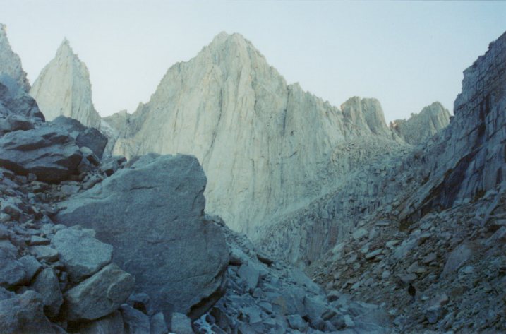
ridge eventually flattened out and soon we reached Iceberg Lake, right at the foot of Mount Whitney. From this
angle Mount Whitney's main body is almost as thin as its two subpeaks Keeler and Day Needles, very impressive and
intimidating. I could see the snow covering the couloir of the Mountaineer's route directly above us. On the right side
behind Iceberg Lake I also saw the low gap (Whitney-Russell Pass) on the Sierra Crest that is convenient for accessing
Whitney's North Slope route. I decided not to attempt Mountaineer's route, knowing the new snow fall and its position in
the shadow would make the steep couloir icy and dangerous. It was already noon time, thinking about the difficult
route finding we must do to get back to car and the long drive home, I was convinced we had no time for the
North Slope route either.
However, Vladimir was very anxious to get to the summit.
Knowing that the Mountaineer's route is the most direct route to the summit and seeing it right in front of him,
he was convinced he could do it in one hour.
After some arguments I decided to let him go alone since I believed in his survival abilities, and I also hoped
he would turn back after seeing the condition of the couloir. If I went with him I would slow him down too much,
besides possibly not be able to negotiate difficult sections. I lent him my gloves, and he gave me his cell phone number,
but we made no agreements about when to head back down.
It was 12:40 pm, Vlad went quickly up the couloir, surmounting the difficult-looking rock
sections while I watched from below. He took about one hour 10 minutes to complete the couloir, then he crossed the notch
to the west side of the mountain, disappearing from my view.
I waited for 2-3 hours, getting impatient
and worried since I hadn't seen him reappear in the couloir coming down. Since there were quite a few people in the area on different
routes, I wasn't too worried about his safety, but nonetheless annoyed that he didn't move more quickly.
One potential danger
was that since he was totally unfamiliar with Whitney's other routes, he could easily get lost if he tried to come down
a different way. It was getting colder and I started walking around to warm up, and
conversing with some people camping at Iceberg Lake. I tried to call and finally got through to Vlad. He
said the route above the couloir on the west side was very difficult and it took him a long time, but he already
reached summit and
was coming down immediately. After the call it took one more hour before he finally showed up in the couloir.
It was
5 pm and we were hopelessly late. The implication was that we would have to hike down in the evening and drive back
all night
in order not to miss work on Monday morning. It was already evident no sleep would be possible tonight.
I had already scouted out the easier use trail that the backpackers took to descend from Iceberg Lake. Immediately
after Vlad got down the Mountaineer's route we kept walking down fast. Vlad was totally exhausted, and told
me how dangerous the icy chutes on the west side of the couloir were. He said he almost fell but was caught by his foot
in a crack. He was feeling cold as well, having been in
icy winds and the shady chutes for 4 hours and 40 minutes. Fortunately we were able to follow the easiest
possible trail all the way down to the Lower Boyscout Lake basin without losing the trail once. We were able
to see how we missed the trail on the way up at several spots. By the time we were near our camp spot, it was almost
dark. We needed a good way to reach the camp spot, which is across the creek. Vlad remembered the route we took
in the morning, so he lead me through some bushes. When trying to cross a long sloping slab, I panicked and decided
to go around it. After some bush-wacking I managed to step both feet into a shallow pond.
I cursed and complained, and shouted to Vlad to ask for direction several times, before finally reaching
the tent in pitch darkness with my headlamp on. The daunting difficulty of cross-country route-finding in the dark
even with a headlamp has already reared its ugly head.
In the tent we rested and ate some. Vlad was not feeling well at all, I suspected hypothermia and exhaustion.
He had no appetite and felt very cold. I was anxious knowing how late we were and facing the prospect of not being able to make
it back to work on Monday. However, I also knew that if Vlad was sick with hypothermia, we should wait till the
morning to avoid making him sicker. We probably rested two hours in the tent, and finally Vlad was in good enough shape
to go at
around 10:30 pm. After reluctantly putting on my cold water-soaked socks and shoes, we packed the tent and started
trudging very slowly trying to find the easiest cross-country route to the trails with flashlights.
It actually worked out, as we were at the Lower Boy Scout Lake's trail junction (where we sheltered from snow the
previous day) in less than an hour without serious trouble.
Next, the most painful experience in my hiking life occurred. We left Lower Boy Scout Lake and started going down the
drainage, only about 2 miles to the trailhead. We picked the best looking trail forks under flashlights, and after descending
much elevation, we found ourselves in the bush with nowhere to go. We patiently back-tracked and explored a handful of
trail forks, all leading to nowhere. It was most discouraging. We back-tracked more, ascending back up further and got
pretty exhausted, now already past midnight. Sometimes we even got lost back-tracking! I was almost falling asleep,
had to rest frequently, and cursing all the time. Vlad was anxious to
get back in order not to miss meetings and classes on Monday. We decided to take a fork in the direction of the ledges,
and reached a dangerous section along the cliff edge. I was sure we didn't go through this on the way up. We
arrived at a point on the ledges with many cairns, but after exploring all possibilities simply couldn't find a way to
go further! I was in dispair, now knowing it's not possible to make it back in time. There was no end to the misery,
as if the place was haunted by demons. At one point we saw lights in the lower
part of the drainage; maybe people were trying to rescue us? Soon we realized these were hikers on their way up
using headlamps, it would take them two hours to reach where we were, if they did not get lost. We back-tracked further,
all the way
back to Lower Boy Scout Lake. There was still no sign of the right route. I
said enough, let's sleep here. We needed to sleep so we would have energy to go back when the sun rises in only 3-4 hours.
Vlad tried to analyze his digital photos taken on the way up to figure out how we made it up there.
Finally I convinced him to accept our situation, hoping that other hikers could help us in the morning,
and maybe we would have better luck in daylight.
We set up camp at the place where the trail forks (the exact same location we stayed for shelter the previous day),
hoping hikers coming up the trail in the morning would wake us up.
Without any fuss we immediately went to sleep, at around 3:30 am.
In the morning of Monday the 30th of September, a group of day-hikers passed by our tent, and Vlad opened the door to
talk to them. They seemed to have
been here many times and the guy mentioned that the route we took to the ledges were correct. He said there were in fact
two parallel trails on the ledges, one on the edge and one further up. That explained why the trail we took the previous
night did not look like the one we took on the way up. Still unsure how we would be able to find the correct route, we
nonetheless quickly packed up after drinking hot tea and making attempts to dry our socks. It felt awful to put on my socks
and shoes, but a bit later it was all fine as the morning warms up. We followed the same trail down as we did during
the night, paying close attention
to any new unexplored forks. We found one higher on the ledges, and this was exactly the trail we took on the way up.
Following
this trail we reached the same ledge area with many cairns as the previous night. After some exploring we again reached a
dead end. I was so disappointed. I cursed while resting on a rock. I tried to call work on my cell phone but the call
was cut off because of low battery. We continued exploring on the dangerous exposed ledges, and Vlad
indicated the next ledge below was promising. I found a duck marking a 10 feet class 3 chimney leading down.
After more false leads we finally descended the
Ebersbacher ledges which involved more class 3 down climbing. Further down the trail was
straight-forward, and we made it to car at around 10:30 am, taking about two hours from our camp.
We called work from the pay phone at the trailhead, then started on the long drive to Bay Area, which took 7 and half
hours. What an epic trip! And we sure learned some lessons.
Mount Whitney is not to be taken lightly. We will be back again, armed with better knowledge about the route, and
hopefully in good weather.
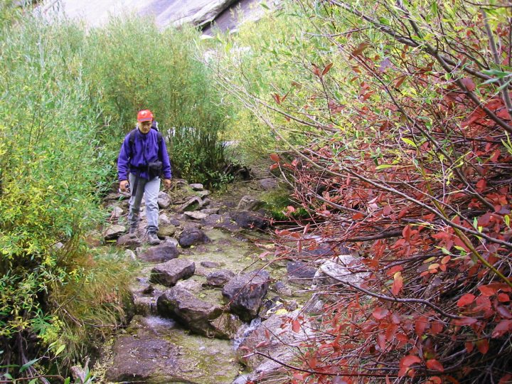
- Crossing the North Fork Lone Pine Creek amid fall color.
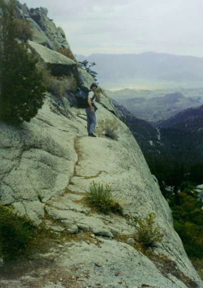
- Vlad at the edge of a narrow ledge.
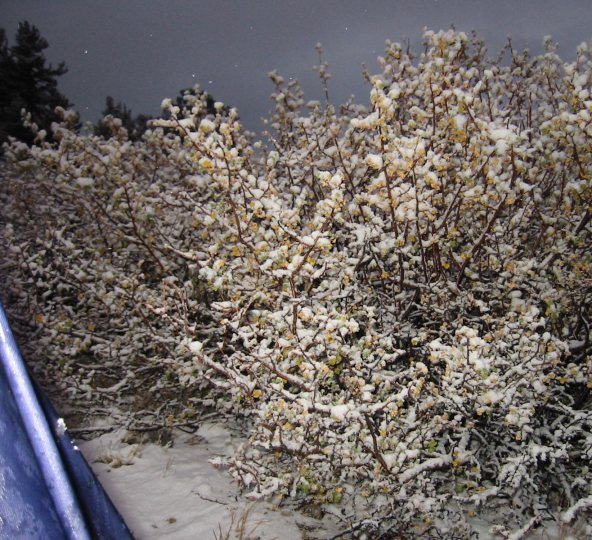
- Looking out of our tent at dusk, after the snow storm.
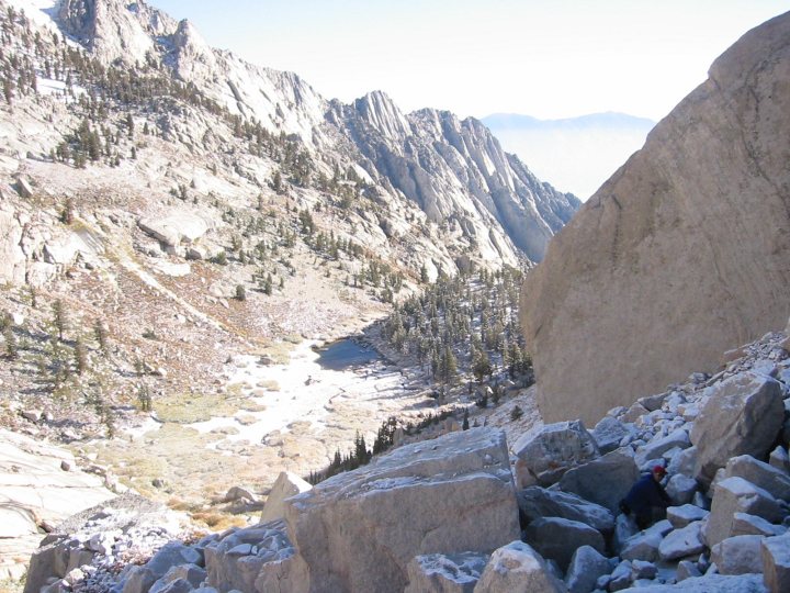
- Climbing talus above Lower Boy Scout Lake.
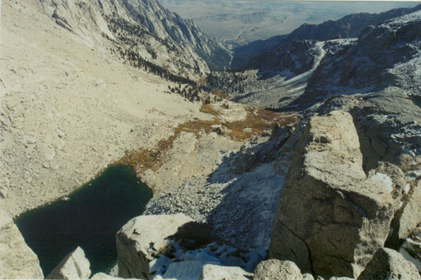
- Looking over Upper Boy Scout Lake from the cliffs leading to Iceberg Lake.
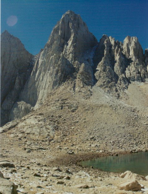
- Iceberg Lake and Mount Whitney.
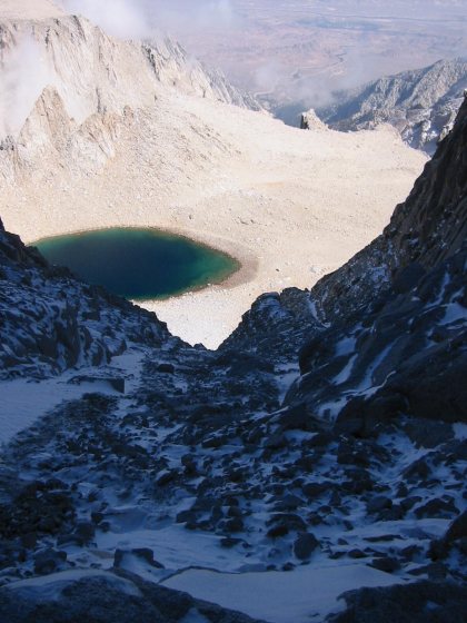
- Looking down from the snow-covered steep chute on the Mountaineer's Route.
Iceberg Lake is straight down, the town of Lone Pine at upper right horizon.
- Mount Whitney at dusk, seen from the moraine valley below Iceberg Lake.
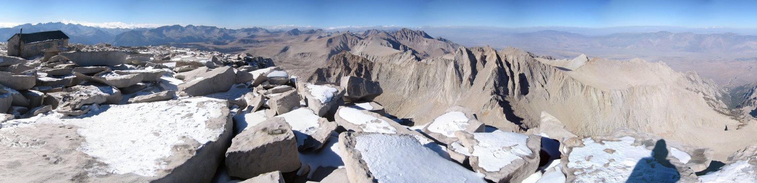
- Northern panorama from the summit: from left to right
are the high Kaweah Peaks, Great Western Divide, King-Kern Divide, Mount Williamson (center), Mount Russell
(center-right foreground), and North Fork Lone Pine Creek drainage which was our ascent route.
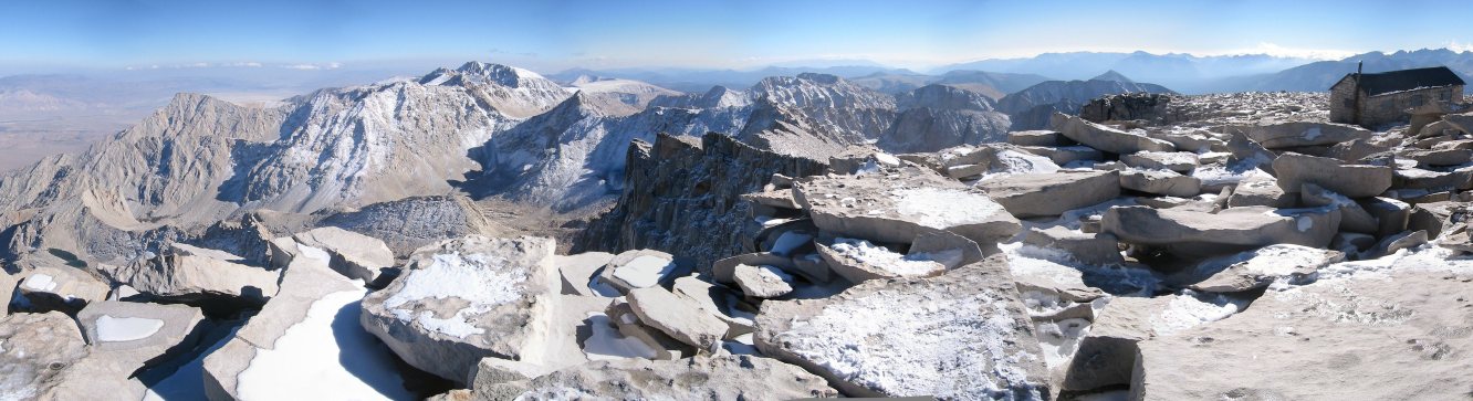
- Southern panorama from the summit: from left to right
are Lone Pine Peak, Mount Langley, Olancha Peak, Mount Muir, Great Western Divide (Mineral King area), and the high
Kaweah peaks.
