 Vladimir Ulyashin and I went on a backpacking and climbing trip to Kuna Peak in southeastern Yosemite National
Park on October 14-15, 2000. Our goal was climbing 13002' (3963 m) Kuna Peak, the third highest peak in the park.
The trip goes south from the Mono Pass / Parker Pass trailhead on Tioga Road a few miles west of Tioga Pass (~~9600'),
gently ascending a wide forested valley along the rushing waters of Parker Pass Creek. There was a light snow storm
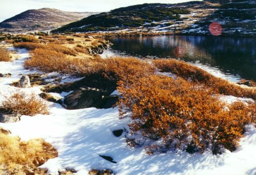
the previous week, much of the area was covered by up to 6" of new snow. We crossed several large, open meadows
with beautiful golden colored grasses, bordered by islands of low bushes with brilliant orange colors. Taking the
signed trail branch toward Spillway Lake, we reached it after walking about 5 miles, where the trail disappears.
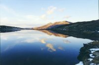
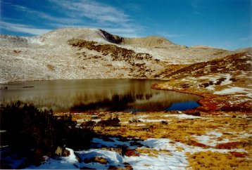
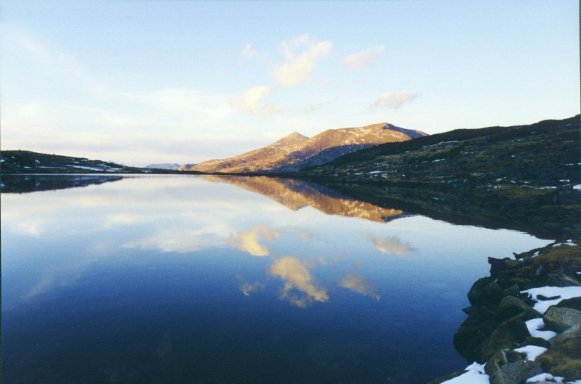
Continuing up-valley, we ascended a glacial bench to the large, round Helen Lake (10945'), bordered by gently rolling
meadows in a wide cirque of Kuna Crest. This would be our camp site. Overnight it was full moon outside, the withered
grasses covered with frost and snow crystals glittering in the bright light.
Vladimir Ulyashin and I went on a backpacking and climbing trip to Kuna Peak in southeastern Yosemite National
Park on October 14-15, 2000. Our goal was climbing 13002' (3963 m) Kuna Peak, the third highest peak in the park.
The trip goes south from the Mono Pass / Parker Pass trailhead on Tioga Road a few miles west of Tioga Pass (~~9600'),
gently ascending a wide forested valley along the rushing waters of Parker Pass Creek. There was a light snow storm
the previous week, much of the area was covered by up to 6" of new snow. We crossed several large, open meadows
with beautiful golden colored grasses, bordered by islands of low bushes with brilliant orange colors. Taking the
signed trail branch toward Spillway Lake, we reached it after walking about 5 miles, where the trail disappears.
Continuing up-valley, we ascended a glacial bench to the large, round Helen Lake (10945'), bordered by gently rolling
meadows in a wide cirque of Kuna Crest. This would be our camp site. Overnight it was full moon outside, the withered
grasses covered with frost and snow crystals glittering in the bright light.
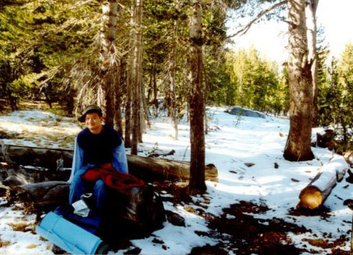
The next morning we started climbing before my frozen boots had fully softened in the sun yet. We ascended the
1700' ridge on the east side of the lake, which is the northwest ridge of Kuna Peak. It was a steep talus slog
over mostly dark-grey metamorphic rock, some times jet black and some times reddish-brown. Once on top of the ridge,
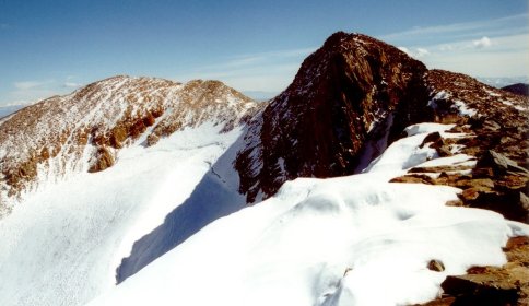
we got our first glimpse of Kuna Peak, which is flanked on both sides by peaks of almost equal height (12962' Koip
Peak on the east and an unnamed peak on the west). Kuna Peak faces its glacier with a series of overhanging buttresses,
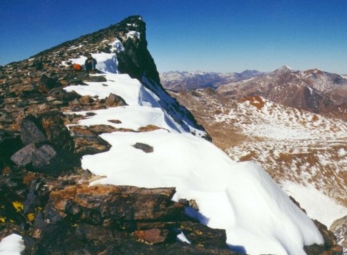
and its west side features a 100' gap that separates it from the unnamed peak. We traversed the ridge line towards
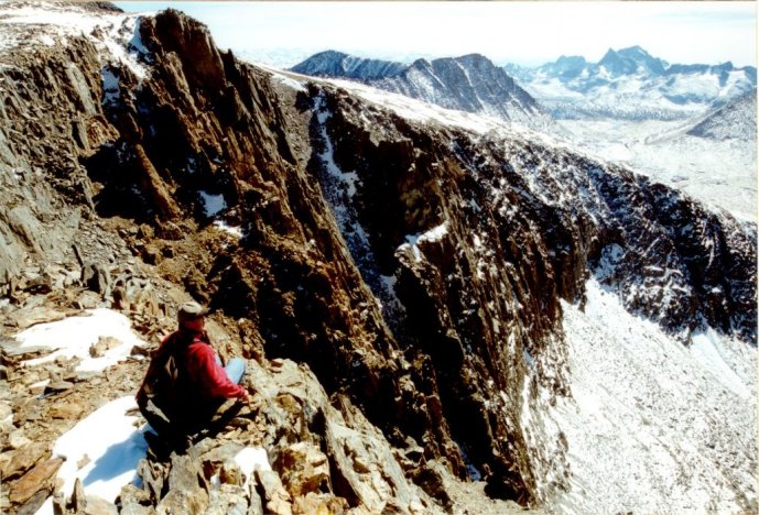
the summit, skirting the minor humps on the mostly level northwest ridge. The exposure on both sides of the ridge
got more extreme, and soon we were looking down spectacular chutes that lead to Lyell Canyon, with great close-up
views on the west side to 13114' Mt Lyell, the highest peak in Yosemite. On the other side the cliff-edge was covered
by snow cornices that drop precipitously to the Kuna-Koip glacier.
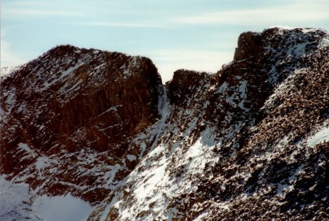
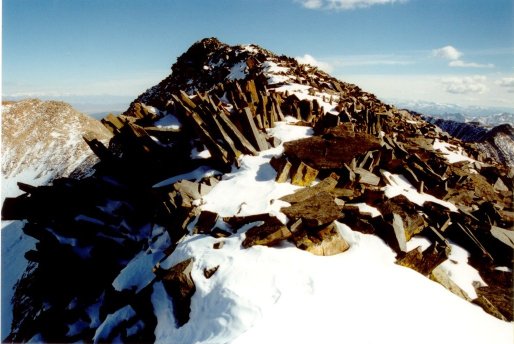
We skirted the unnamed peak and reached the 100' gap after walking over lots of knife-like pieces of rocky flakes
sticking straight up. The gap is a thin ridge of about 10' long, 2' wide, with nearly vertical chutes on both sides.
Across the gap is a vertical buttress that leads to the summit plateau of Kuna Peak. The buttress features a wide
expanse of smooth rock on the right (southern side) and multiple narrow snow chutes approaching 70 degrees on the
left. Vlad descended into the gap first. The descent was quite treacherous as the rock was smooth and steep. Then
he climbed up the buttress through an almost vertical snow chute on the left with horrendous exposure. Once above
the snow chute the going looked easier, with a series of stair steps but still with ridiculous exposure. This is
probably the part rated class 3 by RJ Secor.
I carefully descended into the gap, then attempted to climb up the same snow chute. The rock was freezing cold,
and I got a cut on a finger from a particularly sharp piece. I pulled out the first aid pack and wrapped it in
band-aid. I climbed up half-way in the chute, but I was losing my grip due to my cold hands, and adequate footing
was non-existent on the vertical, snow-slicked buttress. So I retreated, and told Vlad to go on to the summit himself.
I retreated to the unnamed peak where I could see the summit of Kuna Peak, and I saw him there. After a while I
was back at the other side of the gap looking over while Vlad retraced his steps back down the same buttress. It
was so vertical that he often could not see the next step. Finally he made it safely back across the gap, according
to him there was another airy knife-edge on the summit plateau before reaching the summit. A summit register was
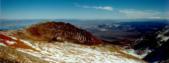
not found on Kuna Peak. It was 3:20 pm, about 6 hours after we started. We took in great close-up views of the
Mt Ritter group south of Lyell, snow-capped White Mountains to the east, Mono Lake, as well as multitudes of ranges
and peaks of the southern High Sierra.
The way back was long and tedious over a lot of talus. When we reached Helen Lake to pick up our camp stuff
the sun was setting. We walked the 6-7 miles to car mostly in the dark, carefully following the trail where it
exists and avoiding the swamps. Some pictures of this trip:
